Cyclonic Storm Ditwah: Heavy Rainfall Expected Across Coastal Andhra Pradesh and Rayalaseema Regions
- Date & Time:
- |
- Views: 37
- |
- From: India News Bull

An orange alert has been issued for north Tamil Nadu, Puducherry and adjoining south Andhra Pradesh coasts as cyclonic storm Ditwah approaches.
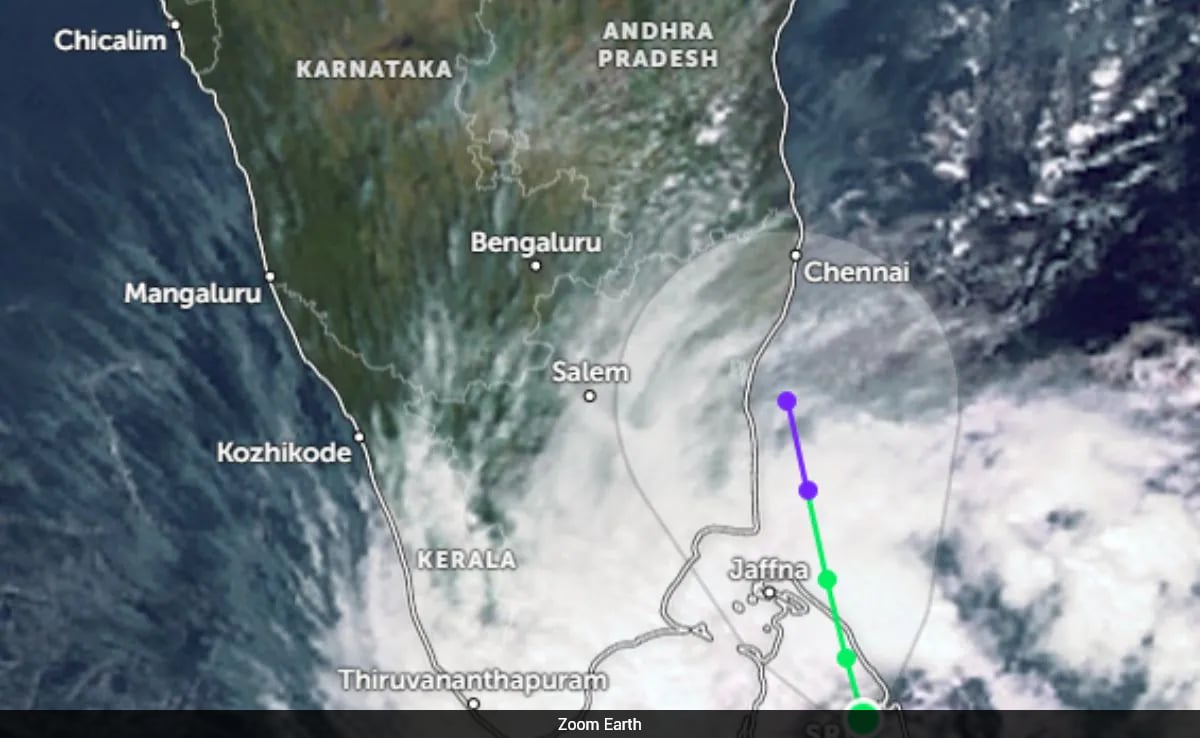
Amaravathi authorities warn that Coastal Andhra and Rayalaseema regions should prepare for heavy rainfall this weekend due to the impending cyclonic storm Ditwah. Currently positioned over the Southwest Bay of Bengal near Sri Lanka's coast, the system is approximately 80 km from Trincomalee (Sri Lanka), 480 km from Puducherry, and 580 km from Chennai.
Prakhar Jain, Managing Director of the Andhra Pradesh State Disaster Management Authority, reported that the cyclone has been moving at 8 km per hour over the past six hours. "The storm is expected to reach the Southwest Bay of Bengal—near North Tamil Nadu, Puducherry, and South Andhra coastal areas—within two days," Jain stated.
He emphasized that the cyclone's impact will likely bring significant precipitation to Coastal Andhra and Rayalaseema regions in the coming days. Maritime safety advisories have been issued, with fishermen urged to avoid sea ventures and farmers recommended to implement protective measures for their agricultural operations.
The India Meteorological Department (IMD) heightened its warning on Friday by issuing an orange alert covering north Tamil Nadu, Puducherry, and neighboring south Andhra Pradesh coastlines. The cyclonic storm continues its north-northwestward trajectory over coastal Sri Lanka and the adjacent southwest Bay of Bengal.
According to the IMD bulletin, Ditwah has intensified, bringing strong winds and potential for extreme rainfall. The system is projected to reach the southwest Bay of Bengal near North Tamil Nadu, Puducherry, and south Andhra Pradesh coasts by early November 30, prompting widespread precautionary notices for residents in coastal regions.
IMD data shows Ditwah moved at 10 kmph during the previous six hours and was located at latitude 8.1°N and longitude 81.2°E as of 0230 hrs IST on Friday. This positions it approximately 50 km south of Trincomalee, 70 km northwest of Batticaloa, 220 km north of Hambantota, 460 km south-southeast of Puducherry, and 560 km south-southeast of Chennai.
Forecasters predict the cyclone will maintain its north-northwestward path along Sri Lanka's coastline and adjoining waters before emerging into the Bay of Bengal.
Vizag Cyclone Warning Centre Officer Jagannath Kumar has activated alerts as Ditwah is anticipated to intensify rainfall patterns and wind conditions throughout coastal Andhra Pradesh over the next six days.
Kumar cautioned that northern and southern coastal districts will experience various phases of precipitation, ranging from isolated to widespread rainfall, accompanied by thunderstorms. He added that maritime warnings have been issued to fishermen against venturing into increasingly dangerous seas with strengthening squally winds.
In his Thursday statement to ANI, Kumar explained, "Under this system, light to moderate rainfall is anticipated across coastal districts. The distribution of rainfall is expected to increase over the coastal region during the next six days, particularly affecting north coastal Andhra Pradesh."
He detailed a progressive rainfall pattern for the northern areas: dry conditions on day one; isolated precipitation on day two; scattered rainfall on day three; and fairly widespread precipitation from days four through six. By the seventh day, rainfall should diminish to a scattered distribution.
Regarding southern Coastal Andhra Pradesh, Kumar forecasted isolated rain beginning on day one, expanding to scattered showers by the second day.
"Initially, dry weather will prevail. By the second day, isolated rainfall will develop, becoming scattered by the third day. Widespread precipitation is highly likely during the third, fourth, and fifth days. Subsequently, intensity and distribution should decrease, becoming fairly widespread on day six and scattered by day seven," he elaborated.
Thunderstorms with lightning are predicted across coastal Andhra Pradesh and Rayalaseema between the second and fifth days of the weather system's progression.
"Thunderstorm activity with lightning is expected over coastal Andhra Pradesh and Rayalaseema from day two through day five. Squally conditions with wind speeds of 35 to 45 kmph are likely along and off south Andhra Pradesh's coast on the first day. Subsequently, wind velocities are expected to increase along Andhra Pradesh's coastline. Consequently, fishermen are strongly advised against maritime activities along and off Andhra Pradesh's coastal waters," Kumar warned.
Source: https://www.ndtv.com/india-news/cyclone-ditwah-heavy-rain-expected-in-coastal-andhra-rayalaseema-tomorrow-and-day-after-9713974